Sham Shui Po
深水埗區 | |
|---|---|
| Sham Shui Po District | |
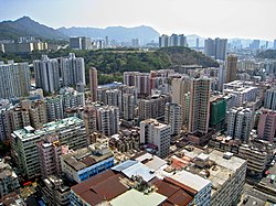
 Day view of the Sham Shui Po District skyline | |
 | |
 Location of Sham Shui Po within Hong Kong | |
| Coordinates: 22°19′51″N 114°09′44″E / 22.33074°N 114.16220°E | |
| Statutorily-defined area | Kowloon (Stonecutters' Island), New Kowloon (mainland) |
| Region | Hong Kong (special administrative region) |
| Country | China |
| Constituencies | 21 |
| Government | |
| • District Council chairman | Chum Tak Shing[needs update] (ADPL) |
| • District Council Vice-chairwoman | Janet Ng |
| • District Officer | Damian Kwok-hung Lee |
| Area | |
• Total | 9.48 km2 (3.66 sq mi) |
| Population (2016[1]) | |
• Total | 405,869 |
| • Density | 43,000/km2 (110,000/sq mi) |
| Time zone | UTC+8 (Hong Kong Time) |
| Largest neighbourhood by population | Sham Shui Po (60,161 – 2016 est)[2] |
| Location of district office and district council | 303 Cheung Sha Wan Road, Sham Shui Po |
| Sham Shui Po District | |||||||||||||||
|---|---|---|---|---|---|---|---|---|---|---|---|---|---|---|---|
| Traditional Chinese | 深水埗區 | ||||||||||||||
| Simplified Chinese | 深水埗区 | ||||||||||||||
| Cantonese Yale | Shāmshéuibóu kēui | ||||||||||||||
| |||||||||||||||
Sham Shui Po District is one of 18 districts of Hong Kong. It is the second poorest district by income in Hong Kong, with a predominantly working-class population of 405,869 in 2016 and the lowest median household income of all districts.[3] Sham Shui Po has long been home to poorer new immigrants from China. It also saw the birth of public housing in Hong Kong, as the government sought to resettle those displaced by a devastating fire in its slums. Sham Shui Po also hosted a Vietnamese refugee camp during the influx of migration in the aftermath of the Vietnam War in the 1970s.
The district covers the Shek Kip Mei, Sham Shui Po, Cheung Sha Wan, Lai Chi Kok, Kowloon Tsai,[clarify] So Uk, Un Chau, Tai Wo Ping and Yau Yat Chuen areas of New Kowloon, and Stonecutters Island of Kowloon.
- ^ "2016 Population Census: Summary Results Table A201a Population by District Council District and Year" (in English and Chinese). Census and Statistics Department, Hong Kong Government. 2016. Retrieved 24 May 2018.
- ^ District Profiles, Hong Kong Government, 8 December 2017, retrieved 15 April 2020
- ^ Basic Tables for District Council Districts: Hong Kong 2006 By-Census