Shamong Township, New Jersey | |
|---|---|
 Samuel Richards Mansion in Atsion, a settlement within Shamong Township | |
 Shamong Township highlighted in Burlington County. Inset map: Burlington County highlighted in the State of New Jersey. | |
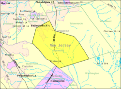
 Census Bureau map of Shamong Township, New Jersey | |
Location in Burlington County Location in New Jersey | |
| Coordinates: 39°47′06″N 74°43′02″W / 39.78500°N 74.71718°W[1][2] | |
| Country | |
| State | |
| County | |
| Incorporated | February 19, 1852 |
| Government | |
| • Type | Township |
| • Body | Township Committee |
| • Mayor | Michael Di Croce (R, term ends December 31, 2023)[3][4] |
| • Administrator / Municipal clerk | Susan Onorato[5] |
| Area | |
• Total | 45.01 sq mi (116.58 km2) |
| • Land | 44.45 sq mi (115.14 km2) |
| • Water | 0.56 sq mi (1.44 km2) 1.24% |
| • Rank | 41st of 565 in state 6th of 40 in county[1] |
| Elevation | 56 ft (17 m) |
| Population | |
• Total | 6,460 |
| 6,503 | |
| • Rank | 329th of 565 in state 25th of 40 in county[11] |
| • Density | 145.3/sq mi (56.1/km2) |
| • Rank | 523rd of 565 in state 35th of 40 in county[11] |
| Time zone | UTC−05:00 (Eastern (EST)) |
| • Summer (DST) | UTC−04:00 (Eastern (EDT)) |
| ZIP Code | 08088[12] |
| Area code(s) | 609 exchanges: 268, 801, 859[13] |
| FIPS code | 3400566810[1][14][15] |
| GNIS feature ID | 0882084[1][16] |
| Website | www |
Shamong Township is a township in Burlington County, in the U.S. state of New Jersey. As of the 2020 United States census, the township's population was 6,460,[8][9] a decrease of 30 (−0.5%) from the 2010 census count of 6,490,[17][18] which in turn reflected an increase of 28 (+0.4%) from the 6,462 counted in the 2000 census.[19] The township, and all of Burlington County, is a part of the Philadelphia-Reading-Camden combined statistical area and the Delaware Valley.[20]
Shamong was incorporated as a township by an act of the New Jersey Legislature on February 19, 1852, from portions of Medford, Southampton and Washington townships. Portions of the township were taken to form Woodland Township (March 7, 1866) and Tabernacle Township (March 22, 1901).[21] In April 1902, portions of Hammonton and Waterford Township were annexed to the township.[22] The township's name comes from Native American terms meaning "place of the big horn", from the words oschummo ("horn") and onk ("place").[23][24]
New Jersey Monthly magazine ranked Shamong Township as its 6th best place to live in its 2008 rankings of the "Best Places To Live" in New Jersey.[25]
- ^ a b c d e 2019 Census Gazetteer Files: New Jersey Places, United States Census Bureau. Accessed July 1, 2020.
- ^ US Gazetteer files: 2010, 2000, and 1990, United States Census Bureau. Accessed September 4, 2014.
- ^ Cite error: The named reference
Officialswas invoked but never defined (see the help page). - ^ 2023 New Jersey Mayors Directory, New Jersey Department of Community Affairs, updated February 8, 2023. Accessed February 10, 2023.
- ^ Administration & Clerk's Office, Shamong Township. Accessed April 25, 2023.
- ^ Cite error: The named reference
DataBookwas invoked but never defined (see the help page). - ^ U.S. Geological Survey Geographic Names Information System: Township of Shamong, Geographic Names Information System. Accessed March 14, 2013.
- ^ a b c Cite error: The named reference
Census2020was invoked but never defined (see the help page). - ^ a b Cite error: The named reference
LWD2020was invoked but never defined (see the help page). - ^ Cite error: The named reference
PopEstwas invoked but never defined (see the help page). - ^ a b Population Density by County and Municipality: New Jersey, 2020 and 2021, New Jersey Department of Labor and Workforce Development. Accessed March 1, 2023.
- ^ Look Up a ZIP Code for Shamong, NJ, United States Postal Service. Accessed August 30, 2012.
- ^ Area Code Lookup - NPA NXX for Shamong, NJ, Area-Codes.com. Accessed December 1, 2013.
- ^ U.S. Census website, United States Census Bureau. Accessed September 4, 2014.
- ^ Geographic Codes Lookup for New Jersey, Missouri Census Data Center. Accessed April 1, 2022.
- ^ US Board on Geographic Names, United States Geological Survey. Accessed September 4, 2014.
- ^ Cite error: The named reference
Census2010was invoked but never defined (see the help page). - ^ Cite error: The named reference
LWD2010was invoked but never defined (see the help page). - ^ Table 7. Population for the Counties and Municipalities in New Jersey: 1990, 2000 and 2010, New Jersey Department of Labor and Workforce Development, February 2011. Accessed May 1, 2023.
- ^ New Jersey: 2020 Core Based Statistical Areas and Counties, United States Census Bureau. Accessed February 1, 2023.
- ^ Snyder, John P. The Story of New Jersey's Civil Boundaries: 1606-1968, Bureau of Geology and Topography; Trenton, New Jersey; 1969. p. 99. Accessed May 30, 2024.
- ^ Honeyman, Abraham Van Doren. Index-analysis of the Statutes of New Jersey, 1896-1909: Together with References to All Acts, and Parts of Acts, in the 'General Statutes' and Pamphlet Laws Expressly Repealed: and the Statutory Crimes of New Jersey During the Same Period, p. 256. New Jersey Law Journal Publishing Company, 1910. Accessed October 2, 2015.
- ^ Hutchinson, Viola L. The Origin of New Jersey Place Names, New Jersey Public Library Commission, May 1945. Accessed October 2, 2015.
- ^ Gannett, Henry. The Origin of Certain Place Names in the United States, p. 28. United States Government Printing Office, 1905. Accessed October 2, 2015.
- ^ "Best Places To Live - The Complete Top Towns List 1-100" Archived 2008-02-28 at the Wayback Machine, New Jersey Monthly, February 21, 2008. Accessed February 24, 2008.


