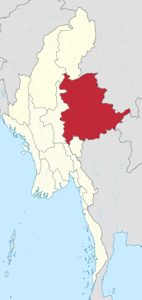
Shan State
| |
|---|---|
 Location of Shan State in Myanmar | |
| Coordinates: 21°30′N 98°0′E / 21.500°N 98.000°E | |
| Country | Myanmar |
| State | East central |
| Before becoming State | Federated Shan States |
| Establishment | 4 January 1948 |
| Direct rule by the Government | 1 October 1959 |
| Capital | Taunggyi |
| Government | |
| • Chief Minister | Kyaw Kyaw Tun |
| • Cabinet | Shan State Government |
| • Legislature | Shan State Hluttaw |
| • Judiciary | Shan State High Court |
| Area | |
• Total | 155,801.3 km2 (60,155.2 sq mi) |
| • Rank | 1st |
| Highest elevation | 2,641 m (8,665 ft) |
| Population (2014)[2] | |
• Total | 5,824,432 |
| • Rank | 4th |
| • Density | 37/km2 (97/sq mi) |
| The last official census in Myanmar was in 2014. | |
| Demonym | Shan |
| Demographics | |
| • Ethnicities | |
| • Religions |
|
| Time zone | UTC+06:30 (MMT) |
| HDI (2019) | 0.509[3] low · 14th |
| Website | www |
Shan State (Shan: မိူင်းတႆး, Möng Tai; Burmese: ရှမ်းပြည်နယ်, pronounced [ʃáɰ̃ pjìnɛ̀]) is a state of Myanmar. Shan State borders China (Yunnan) to the north, Laos (Louang Namtha and Bokeo Provinces) to the east, and Thailand (Chiang Rai, Chiang Mai and Mae Hong Son Provinces) to the south, and five administrative divisions of Myanmar in the west. The largest of the 14 administrative divisions by land area, Shan State covers 155,800 km2, almost a quarter of the total area of Myanmar. The state gets its name from the Burmese name for the Tai peoples: "Shan people". The Tai (Shan) constitute the majority among several ethnic groups that inhabit the area. Shanland is largely rural, with only three cities of significant size: Lashio, Kengtung, and the capital, Taunggyi.[4] Taunggyi is 150.7 km northeast of the nation's capital Naypyitaw.
The Shan state, with many ethnic groups, is home to several armed ethnic groups. While the military government has signed ceasefire agreements with most groups, vast areas of the state, especially those east of the Salween River, remain outside the central government's control, and in recent years have come under heavy ethnic-Han Chinese economic and political influence. Other areas are under the control of military groups such as the Shan State Army.
According to data from the United Nations Office on Drugs and Crime (UNODC), Shan State is the region that produces the most opium in Myanmar, though production has declined in recent years.[5]
- ^ "Union of Myanmar". City Population. Retrieved 25 December 2008.
- ^ Census Report. The 2014 Myanmar Population and Housing Census. Vol. 2. Naypyitaw: Ministry of Immigration and Population. May 2015. p. 17.
- ^ "Sub-national HDI – Area Database – Global Data Lab". hdi.globaldatalab.org. Retrieved 13 September 2018.
- ^ "Shan: largest cities and towns and statistics of their population". World Gazetteer. Retrieved 19 January 2008.[dead link]
- ^ "Myanmar Opium Survey 2020: Cultivation, Production and Implications" (PDF). February 2021.
