| Shavers Fork | |
|---|---|
 Shavers Fork at Stuart Recreation Area in the Monongahela National Forest | |
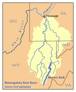
 Map of the Monongahela River basin, with Shavers Fork highlighted. | |
| Location | |
| Country | United States |
| State | West Virginia |
| Counties | Tucker, Randolph, Pocahontas |
| Physical characteristics | |
| Source | Thorny Flat, Cheat Mountain |
| • location | Pocahontas County, West Virginia |
| • coordinates | 38°23′44″N 79°59′02″W / 38.39556°N 79.98389°W[1] |
| • elevation | 4,553 ft (1,388 m)[2] |
| Mouth | Cheat River[1] |
• location | Parsons, West Virginia |
• coordinates | 39°06′39″N 79°40′43″W / 39.11083°N 79.67861°W |
• elevation | 1,621 ft (494 m) |
| Length | 89 mi (143 km)[3] |
| Basin size | 214 sq mi (550 km2)[3] |
| Discharge | |
| • location | Bowden, West Virginia[4] |
| • average | 445 cu ft/s (12.6 m3/s) |
| • minimum | 99 cu ft/s (2.8 m3/s)(1976) |
| • maximum | 27,600 cu ft/s (780 m3/s)(2010) |
| Discharge | |
| • location | Cheat Bridge, WV[5] |
| • average | 188 cu ft/s (5.3 m3/s) |
Shavers Fork of the Cheat River is situated in the Allegheny Mountains of eastern West Virginia, USA. It is 88.5 mi (142.4 km) long[3] and forms the Cheat at its confluence with Black Fork at Parsons.[6] It was traditionally considered one of the five Forks of Cheat and its upper reaches constitute the highest river in the eastern United States.[7]
- ^ a b "Shavers Fork". Geographic Names Information System. United States Geological Survey, United States Department of the Interior. Retrieved 2004-04-24.
- ^ "Shavers Fork Source". Elevation Query. U.S. Geological Survey. Retrieved 2008-04-24.[permanent dead link]
- ^ a b c Godfrey, Tanya. 2006. "Shavers Fork." The West Virginia Encyclopedia. Ken Sullivan, editor. Charleston, WV: West Virginia Humanities Council. ISBN 0-9778498-0-5.
- ^ "USGS 03068800 SHAVERS FORK BELOW BOWDEN, WV". National Water Information System. U.S. Geological Survey. Retrieved 2008-04-24.
- ^ "USGS 03067510 SHAVERS FORK NR CHEAT BRIDGE, WV". National Water Information System. U.S. Geological Survey. Retrieved 2008-04-24.
- ^ DeLorme (1997). West Virginia Atlas & Gazetteer. Yarmouth, Maine: DeLorme. ISBN 0-89933-246-3.
- ^ Bender, Steve (2002) “Cheat River: West Virginia” Southern Living, Southern Progress Corporation, Spring 2002.