| Shawangunk Kill | |
|---|---|
 | |
| Location | |
| Country | United States |
| State | New York |
| Region | Hudson Valley |
| Counties | Orange, Sullivan, Ulster |
| Towns | Greenville, Mamakating, Wawayanda, Wallkill, Crawford, Shawangunk, Gardiner |
| Physical characteristics | |
| Source | Unnamed pond |
| • location | Greenville, New York |
| • coordinates | 41°23′35″N 74°36′10″W / 41.3931°N 74.6029°W |
| • elevation | 1,240 ft (380 m) |
| Mouth | Wallkill River |
• location | W of Gardiner, New York |
• coordinates | 41°41′01″N 74°09′55″W / 41.6835°N 74.1652°W |
• elevation | 180 ft (55 m) |
| Length | 47 mi (76 km) |
| Basin size | 147 sq mi (380 km2) |
| Discharge | |
| • average | 138 cu ft/s (3.9 m3/s) |
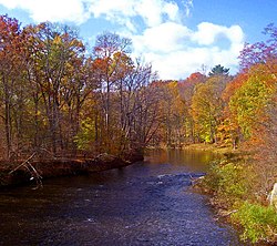
The Shawangunk Kill is a 47.2-mile-long (76.0 km)[1] stream that flows northward through Orange, Sullivan and Ulster counties, New York, in the United States. It is the largest tributary of the Wallkill River.
It takes its name from the neighboring Shawangunk Ridge, where it rises in the town of Greenville, then flowing down into the valley. For part of its length, it forms the northwestern boundary of Orange County, with first Sullivan and then Ulster County along the other side.
- ^ U.S. Geological Survey. National Hydrography Dataset high-resolution flowline data. The National Map, accessed October 3, 2011