Sheakleyville, Pennsylvania | |
|---|---|
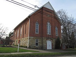
 Church in Sheakleyville | |
 Location of Sheakleyville in Mercer County, Pennsylvania. | |
| Coordinates: 41°26′36″N 80°12′26″W / 41.44333°N 80.20722°W | |
| Country | United States |
| State | Pennsylvania |
| County | Mercer |
| Established | 1820 |
| Area | |
| • Total | 0.20 sq mi (0.51 km2) |
| • Land | 0.20 sq mi (0.51 km2) |
| • Water | 0.00 sq mi (0.00 km2) |
| Elevation [2] (center of borough) | 1,282 ft (391 m) |
| Highest elevation [2] (southern border of borough) | 1,298 ft (396 m) |
| Lowest elevation [2] (Mill Run) | 1,240 ft (380 m) |
| Population | |
| • Total | 151 |
| • Density | 770.41/sq mi (296.94/km2) |
| Time zone | UTC-4 (EST) |
| • Summer (DST) | UTC-5 (EDT) |
| Zip code | 16151 |
| Area code(s) | 724, 878 |
Sheakleyville is a borough in northern Mercer County, Pennsylvania, United States. The population was 142 at the 2010 census,[4] a figure which increased to 150 tabulated residents in 2020.[5] It is part of the Hermitage micropolitan area.
- ^ "ArcGIS REST Services Directory". United States Census Bureau. Retrieved October 16, 2022.
- ^ a b c "Hadley Dam Reservoir Topo Map, Mercer County PA (Greenville East Area)". TopoZone. Locality, LLC. Retrieved 7 September 2019.
- ^ "Census Population API". United States Census Bureau. Retrieved Oct 12, 2022.
- ^ United States Census Bureau. "2010 Census - Sheakleyville Borough data". 2010.census.gov. Archived from the original on 2012-12-21.
- ^ Bureau, US Census. "City and Town Population Totals: 2020-2021". Census.gov. US Census Bureau. Retrieved 18 July 2022.
{{cite web}}:|last1=has generic name (help)
