| Sheldon | |
|---|---|
 | |
Location within the West Midlands | |
| Area | 2.3 sq mi (6.0 km2) |
| Population | 21,817 (2011.Ward) |
| • Density | 9,486/sq mi (3,663/km2) |
| OS grid reference | SP155845 |
| Metropolitan borough | |
| Shire county | |
| Metropolitan county | |
| Region | |
| Country | England |
| Sovereign state | United Kingdom |
| Post town | BIRMINGHAM |
| Postcode district | B26 |
| Dialling code | 0121 |
| Police | West Midlands |
| Fire | West Midlands |
| Ambulance | West Midlands |
| UK Parliament | |
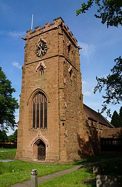
Sheldon is an area of east Birmingham, England. Historically part of Warwickshire, it is close to the border with the Metropolitan Borough of Solihull and Birmingham Airport.
Sheldon is also one of the 69 electoral wards in Birmingham, and one of the four wards that make up the council constituency of Yardley. It covers an area of 2.3 square miles (6.0 km2; 1,500 acres). Areas covered by the ward are Lyndon Green, Well's Green, Sheldon itself and part of Garrett's Green.
Sheldon was mentioned in the Domesday Book as Machitone, meaning "Macca's farm". A Mackadown Farm existed in the area until the First World War, however, it is only remembered through Mackadown Lane, a residential road.[1]
The suburb is home to the 300 acre Sheldon Country Park, a popular local attraction.
- ^ The History of Greater Birmingham - down to 1830, Victor Skipp, 1987, V. H. T. Skipp (ISBN 0-9506998-0-2)
