| Shenandoah River | |
|---|---|
 Crossing the Shenandoah River in Harpers Ferry, West Virginia | |
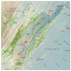
 Shenandoah River drainage basin | |
| Location | |
| Country | United States |
| State | Virginia, West Virginia |
| Towns | Harpers Ferry, WV, Front Royal, VA, Luray, VA |
| Physical characteristics | |
| Source | North Fork |
| • location | Shenandoah Mountain |
| 2nd source | South Fork |
| • location | Port Republic |
| Source confluence | |
| • location | Front Royal, VA |
| Mouth | Potomac River |
• location | Harpers Ferry |
• coordinates | 39°19′21″N 77°43′40″W / 39.3226009°N 77.7277704°W[1] |
• elevation | 246 ft (75 m)[1] |
| Length | 56 mi (90 km) |
| Basin size | 2,937 sq mi (7,610 km2) |
| Discharge | |
| • location | Millville, WV[2] |
| • average | 2,755 cu ft/s (78.0 m3/s) |
| Basin features | |
| Tributaries | |
| • left | North Fork (Shenandoah River) |
| • right | South Fork (Shenandoah River) |
The Shenandoah River /ˌʃɛnənˈdoʊə/ is the principal tributary of the Potomac River, 55.6 miles (89.5 km) long with two forks approximately 100 miles (160 km) long each,[3] in the U.S. states of Virginia and West Virginia. The river and its tributaries drain the central and lower Shenandoah Valley and the Page Valley in the Appalachians on the west side of the Blue Ridge Mountains, in northwestern Virginia and the eastern panhandle of West Virginia.[1] There is a hydroelectric plant along the Shenandoah River constructed in 2014 by Dominion.
- ^ a b c "Shenandoah River". Geographic Names Information System. United States Geological Survey, United States Department of the Interior.
- ^ "USGS 01636500 Shenandoah at Millville, WV" (PDF). National Water Information System. U.S. Geological Survey. 1895–2013. Retrieved May 24, 2014.
- ^ U.S. Geological Survey. National Hydrography Dataset high-resolution flowline data. The National Map, accessed August 15, 2011