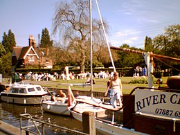
| Shepperton Lock | |
|---|---|
 Shepperton lock (2005) | |
 | |
| 51°22′55.5″N 00°27′31″W / 51.382083°N 0.45861°W | |
| Waterway | River Thames |
| County | Surrey |
| Maintained by | Environment Agency |
| Operation | Hydraulic |
| First built | 1813 |
| Latest built | 1899 |
| Length | 53.16 m (174 ft 5 in) [1] |
| Width | 6.04 m (19 ft 10 in)[1] |
| Fall | 2.03 m (6 ft 8 in)[1] |
| Above sea level | 33 ft (10 m) |
| Distance to Teddington Lock | 10 miles |
| Power is available out of hours | |
Shepperton Lock | |||||||||||||||||||||||||||||||||||||||||||||||||||||||||||||||||||||||||||||||||||||||||||||||||||||||||||||||||||||||||||||||||||||
|---|---|---|---|---|---|---|---|---|---|---|---|---|---|---|---|---|---|---|---|---|---|---|---|---|---|---|---|---|---|---|---|---|---|---|---|---|---|---|---|---|---|---|---|---|---|---|---|---|---|---|---|---|---|---|---|---|---|---|---|---|---|---|---|---|---|---|---|---|---|---|---|---|---|---|---|---|---|---|---|---|---|---|---|---|---|---|---|---|---|---|---|---|---|---|---|---|---|---|---|---|---|---|---|---|---|---|---|---|---|---|---|---|---|---|---|---|---|---|---|---|---|---|---|---|---|---|---|---|---|---|---|---|---|
| |||||||||||||||||||||||||||||||||||||||||||||||||||||||||||||||||||||||||||||||||||||||||||||||||||||||||||||||||||||||||||||||||||||
Shepperton Lock is a lock on the River Thames, in England by the left bank at Shepperton, Surrey.[n 1] It is across the river from Weybridge which is nearby linked by a passenger ferry.
In 1813, the City of London Corporation built the pound lock and the short cuts (cuttings) – the nearer expanded an existing meander cutoff, beyond which lies a fresh cutting and old main stream of the river. These each have associated weirs. Shepperton Weir is between Shepperton Lock Island and Hamhaugh Island; and Shepperton Upper Weir is between Hamhaugh Island and the Hamm Court area of Addlestone, Surrey on the opposite bank.
Upstream of the lock island is the Thames Court pub/restaurant on the near bank, downstream of Pharaoh's Island which was given to Lord Nelson after the Battle of the Nile in 1798. The lock is the fifth from the estuary of the river of a total of forty-five.
- ^ a b c "Environment Agency Dimensions of locks on the River Thames". web page. Environmental Agency. 8 November 2012. Retrieved 18 November 2012. Dimensions given in metres
Cite error: There are <ref group=n> tags on this page, but the references will not show without a {{reflist|group=n}} template (see the help page).