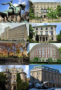
Sheridan-Kalorama Historic District | |
 (left to right) Equestrian statue of Philip Sheridan, Dutch ambassadorial residence, Embassy of China's staff residence, Austrian ambassadorial residence, Mitchell Park, The Dresden, Miller House, Embassy of Luxembourg | |
| Location | Roughly bounded by Rock Creek Park, Connecticut Avenue, Florida Avenue, 22nd Street, and P Street Washington, D.C., U.S. |
|---|---|
| Coordinates | 38°54′56.6″N 77°3′2.7″W / 38.915722°N 77.050750°W |
| Area | 190 acres (77 ha) |
| NRHP reference No. | 89001743[1] |
| Significant dates | |
| Added to NRHP | October 30, 1989 |
| Designated DCIHS | September 25, 1989 |
The Sheridan-Kalorama Historic District is a neighborhood and historic district located in the northwest quadrant of Washington, D.C. The boundaries of the historic district include Rock Creek Park to the north and west, P Street to the south, and 22nd Street and Florida Avenue to the east. On the southwestern edge of the neighborhood is a stretch of Embassy Row on Massachusetts Avenue. The other neighborhood and historic district that lies to the east of Sheridan-Kalorama is Kalorama Triangle Historic District. The two neighborhoods are divided by Connecticut Avenue. For many years both neighborhoods were geographically connected before the stretch of Connecticut Avenue was installed toward the Taft Bridge. Oftentimes, both neighborhoods are simply called "Kalorama" or "Kalorama Heights".
There are two traffic circles in Sheridan-Kalorama: Kalorama Circle and Sheridan Circle. The latter is a park centered on the equestrian statue of General Philip Sheridan. The name "Kalorama" means "fine view" in Greek. There are several parks in Sheridan-Kalorama, including Mitchell Park and the Ukrainian Independence Park. A large number of buildings and sites in the neighborhood are listed on the National Register of Historic Places (NRHP) and District of Columbia Inventory of Historic Sites (DCIHS). Four of these buildings are National Historic Landmarks and over 600 structures are contributing properties to the Sheridan-Kalorama Historic District, which was listed on the NRHP and DCIHS in 1989.
The original inhabitants of present-day Sheridan-Kalorama were the Nacotchtank and Mattawoman tribes. During the 17th century, Sheridan-Kalorama was part of a large estate, named Widow's Mite. Various portions of the land were sold throughout the years, and a large house built in the area was named Belair. The house was renamed Kalorama by Joel Barlow in the early 19th century. The house was commandeered during the Civil War and caught fire in 1865. Due to a sharp increase of the city's population after the war, people began looking beyond the city's boundary, as Sheridan-Kalorama was part of Washington County, D.C., at the time. Some of the lots during this time were developed for housing, often large homes for wealthy people, intellectuals, and high-ranking government and military officials. The District of Columbia Organic Act of 1871 moved the city's boundary to its current size, thus Sheridan-Kalorama joined Washington, D.C.
After Connecticut Avenue was extended north of Florida Avenue, streetcars lines were installed on the road, drawing more people to buy or build houses in the surrounding area. Speculative real estate in the neighborhood began in the 1890s, as ornate rowhouses were built along the neighborhood's main streets. Unlike Kalorama Triangle, which mostly catered to the middle-class, Sheridan-Kalorama catered to the upper-class. The houses in Sheridan-Kalorama were larger and more grand. Some of these rowhouses and the older homes were demolished and replaced with large apartment buildings. One of the most popular architectural styles built in early 20th-century Sheridan-Kalorama was Colonial Revival, although many other styles are represented in the neighborhood. Decatur Circle was renamed Sheridan Circle and large palatial homes were built in the immediate area.
During the Great Depression, many of the mansions and ornate rowhouses were sold to foreign governments. This process has continued for decades and the neighborhood is home to dozens of embassies, ambassadorial residences, and other diplomatic buildings. Many of them are located along Embassy Row or on streets near it. By 1993, almost 200 buildings in the neighborhood were used as diplomatic offices or residences. The neighborhood has attracted these nations due to the prestige and quiet suburban-like setting. Six U.S. presidents have lived in Sheridan-Kalorama, including Barack Obama. Other notable figures who have lived in the neighborhood include justices of the U.S. Supreme Court, members of Congress, presidential secretaries, and military leaders.
- ^ "National Register Information System". National Register of Historic Places. National Park Service. January 23, 2007.