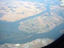
 Sherman Island from the air. The bridge at bottom connects it to Antioch. The small D-shaped island at the top right is Decker Island. | |
| Geography | |
|---|---|
| Location | Sacramento–San Joaquin River Delta |
| Coordinates | 38°03′34″N 121°44′00″W / 38.0593642°N 121.7332878°W |
| Adjacent to | Sacramento-San Joaquin River Delta |
| Area | 14,000 acres (5,700 ha) |
| Length | 9.5 mi (15.3 km) measured SW–NE |
| Width | 3.0 mi (4.8 km) measured SE–NW |
| Demographics | |
| Population | 233 (2000)[1] |
| Additional information | |
| Official website | www |
Sherman Island is an island in the Sacramento-San Joaquin River Delta at the confluence of the two rivers in Sacramento County, California, 1.2 miles (1.9 km) northeast of Antioch. The 5,500 ha (14,000 acres) island, mostly managed by Reclamation District 341,[2] is the meeting point of Sacramento, Solano, and Contra Costa Counties, and is bordered on the north and northwest by the Sacramento River, on the northeast by Three Mile Slough, and on the east, and south west by the San Joaquin River. Sherman Island is a widely known kite and windsurfing area.
Sherman Island was shown, in the same location but with a different shape, on an 1850 survey map of the San Francisco Bay area made by Cadwalader Ringgold[3] and an 1854 map of the area by Henry Lange.[4] Currently, it is 10 feet below sea level, due to the drainage of wetlands in the Delta which has dried out its peat soils, resulting in land subsidence. "In ... parts of Sherman Island, the land has now subsided 25 feet since the late 1800s—and continues to sink between half an inch and 1.5 inches yearly." It is possible that simultaneous levee failures on Sherman Island and surrounding islands, occurring in the wake of an earthquake, could threaten the fresh water supply for the Central Valley.[5]

- ^ Hanson, James C. (May 2009). Sherman Island Five Year Plan SH 08-3.0 (PDF) (Report). Reclamation District 341. Archived (PDF) from the original on 23 June 2010. Retrieved 31 August 2016.
- ^ Cite error: The named reference
SacLAFCOwas invoked but never defined (see the help page). - ^ Ringgold, Cadwalader; Stuart, Fred D.; Everett, Chas.; Harrison (1850). "General Chart embracing Surveys of the Farallones Entrance to the Bay of San Francisco, Bays of San Francisco and San Pablo, Straits of Carquines and Suisun Bay, and the Sacramento and San Joaquin Rivers, to the Cities of Sacramento and San Joaquin, California". David Rumsey Map Collection. San Francisco Common Council. Retrieved 25 February 2021.
- ^ Lange, Henry (1854). "Bai San Francisco und Vereinigung des Sacramento mit dem San Joaquin". David Rumsey Map Collection. George Westermann. Retrieved 25 February 2021.
- ^ Velasquez-Manoff, Moises. "Want to Prevent California's Katrina? Grow a Marsh". Bay Nature. Retrieved 2019-10-19.


