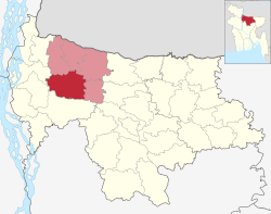
Sherpur Sadar
শেরপুর সদর | |
|---|---|
| Sherpur Sadar | |
 Mai Saheba Jame Masjid | |
 | |
| Coordinates: 25°0′N 90°1′E / 25.000°N 90.017°E | |
| Country | |
| Division | Mymensingh Division |
| District | Sherpur District |
| Headquarters | Sherpur |
| Government | |
| • Mayor | Golam Kibriya Liton |
| • UNO | Firoz Al Mamun |
| Area | |
• Total | 372.89 km2 (143.97 sq mi) |
| Population | |
• Total | 563,865 |
| • Density | 1,500/km2 (3,900/sq mi) |
| Time zone | UTC+6 (BST) |
| Postal code | 2100[2] |
| Area code | 0931[3] |
| Website | Official Website |
Sherpur Sadar (Bengali: শেরপুর সদর) is an upazila of Sherpur District in the Division of Mymensingh, Bangladesh.[4][5][6][7]
- ^ National Report (PDF). Population and Housing Census 2022. Vol. 1. Dhaka: Bangladesh Bureau of Statistics. November 2023. p. 401. ISBN 978-9844752016.
- ^ "Bangladesh Postal Code". Dhaka: Bangladesh Postal Department under the Department of Posts and Telecommunications of the Ministry of Posts, Telecommunications and Information Technology of the People's Republic of Bangladesh. 20 October 2024.
- ^ "Bangladesh Area Code". China: Chahaoba.com. 18 October 2024.
- ^ Sherpur District Statistics 2011
- ^ বাংলাদেশ জাতীয় তথ্য বাতায়ন
- ^ Bangladesher Lokojo Sonskriti Gronthamala : Sherpur, Bangla Academy
- ^ Sakil Ahmed Shahriar Milton (2012), "Sherpur Sadar Upazila", in Sirajul Islam and Ahmed A. Jamal (ed.), Banglapedia: National Encyclopedia of Bangladesh (Second ed.), Asiatic Society of Bangladesh