Shingle Springs | |
|---|---|
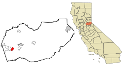
 Location in El Dorado County and the state of California | |
| Coordinates: 38°39′57″N 120°55′34″W / 38.66583°N 120.92611°W | |
| Country | |
| State | |
| County | El Dorado |
| Area | |
| • Total | 8.238 sq mi (21.335 km2) |
| • Land | 8.209 sq mi (21.260 km2) |
| • Water | 0.029 sq mi (0.075 km2) 0.35% |
| Elevation | 1,421 ft (433 m) |
| Population | |
| • Total | 4,660 |
| • Density | 570/sq mi (220/km2) |
| Time zone | UTC-8 (Pacific (PST)) |
| • Summer (DST) | UTC-7 (PDT) |
| ZIP code | 95682 |
| Area code | 530 |
| FIPS code | 06-71554 |
| GNIS feature ID | 1659645 |
| U.S. Geological Survey Geographic Names Information System: Shingle Springs, California | |
| Reference no. | 456 |
Shingle Springs (formerly, Shingle Spring and Shingle)[3] is a census-designated place (CDP) in El Dorado County, California, United States. The population was 4,432 at the 2010 census, up from 2,643 at the 2000 census. It is located about 40 miles (64 km) from Sacramento in the Gold Country foothills and sits directly on Highway 50. The towns of Coloma and Placerville are less than 15 miles (24 km) away.
Shingle Springs is part of the Sacramento–Arden-Arcade–Roseville Metropolitan Statistical Area. The Shingle Springs Band of Miwok Indians, a federally recognized tribe of Maidu and Miwok people, are headquartered in Shingle Springs.[4]
- ^ "2010 Census U.S. Gazetteer Files – Places – California". United States Census Bureau.
- ^ "US Census Bureau". www.census.gov. Retrieved August 10, 2024.
- ^ Durham, David L. (1998). California's Geographic Names: A Gazetteer of Historic and Modern Names of the State. Clovis, Calif.: Word Dancer Press. p. 554. ISBN 1-884995-14-4.
- ^ "Member Tribes." Archived 2012-05-04 at the Wayback Machine California Rural Indian Health Board. Retrieved 31 May 2012.
