志苔館跡 | |
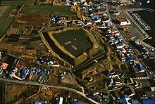
 Aerial view (courtesy of Hakodate City) | |
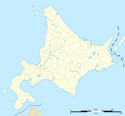
| Location | Hakodate, Hokkaidō, Japan |
|---|---|
| Coordinates | 41°45′57″N 140°49′20″E / 41.765825°N 140.822251°E |
| Altitude | 17 to 25 m (56 to 82 ft) |
| Type | Fortified residence |
| Length | 50 to 65 metres (164 to 213 ft) |
| Width | 70 to 80 metres (230 to 260 ft) |
| Area | 4,100 square metres (44,000 sq ft) (enclosure) 19,960.14 square metres (214,849.2 sq ft) (Historic Site) |
| Site notes | |
| Ownership | National Historic Site |
| Public access | Yes |
The site of Shinoridate (志苔館跡, Shinoridate ato) in Hakodate, Hokkaidō, Japan, is that once occupied by the Shinori Fort or Fortified Residence (as denoted by the tate or date ending). This was the easternmost of the so-called "Twelve Garrisons of Southern Hokkaido", built on the Oshima Peninsula by the Wajin from the fourteenth century.[1][2] The site was designated a National Historic Site in 1934 and is one of the Japan Castle Foundation's Continued Top 100 Japanese Castles.[3][4]
- ^ 史跡志苔館跡 [Shinoridate Site - Historic Site] (in Japanese). Hakodate City. Retrieved 9 September 2019.
- ^ 史跡志苔館跡 [Historic Site: Shinoridate] (in Japanese). MLIT Hokkaido District Transport Bureau. Retrieved 9 September 2019.
- ^ 志苔館跡 [Site of Shinoridate] (in Japanese). Agency for Cultural Affairs. Retrieved 9 September 2019.
- ^ 続日本100名城 [Continued Top 100 Japanese Castles] (in Japanese). Japan Castle Foundation. 29 November 2017. Retrieved 9 September 2019.

