| Shire of Brookton Western Australia | |||||||||||||||
|---|---|---|---|---|---|---|---|---|---|---|---|---|---|---|---|
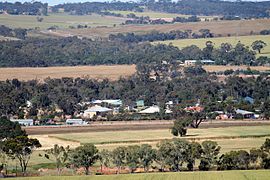
 Brookton from the west | |||||||||||||||
 Location in Western Australia | |||||||||||||||
 | |||||||||||||||
| Population | 929 (LGA 2021)[1] | ||||||||||||||
| Established | 1906 | ||||||||||||||
| Area | 1,601.6 km2 (618.4 sq mi) | ||||||||||||||
| Shire President | Katrina Crute | ||||||||||||||
| Council seat | Brookton | ||||||||||||||
| Region | Wheatbelt | ||||||||||||||
| State electorate(s) | Wagin | ||||||||||||||
| Federal division(s) | O'Connor | ||||||||||||||
| Website | Shire of Brookton | ||||||||||||||
| |||||||||||||||
The Shire of Brookton is a local government area in the Wheatbelt region of Western Australia, about 140 kilometres (87 mi) southeast of Perth, the state capital. The Shire covers an area of 1,602 square kilometres (619 sq mi) and its seat of government is the town of Brookton.
The local economy, worth approximately $25 million per year to the state economy, is based on agriculture - predominantly cereal grains and sheep.[2]
- ^ Australian Bureau of Statistics (28 June 2022). "Brookton (Local Government Area)". Australian Census 2021 QuickStats. Retrieved 28 June 2022.
- ^ Agriculture WA (July 2000). "Agriculture Statistical Overview 96/97 - Shire of Brookton" (PDF). Archived from the original (PDF) on 17 September 2006. Retrieved 15 November 2006.