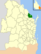
| Shire of Burnett Queensland | |||||||||||||||
|---|---|---|---|---|---|---|---|---|---|---|---|---|---|---|---|
 Location within Queensland | |||||||||||||||
| Population | 27,232 (2006 census)[1] | ||||||||||||||
| • Density | 13.6106/km2 (35.2512/sq mi) | ||||||||||||||
| Established | 1994 | ||||||||||||||
| Area | 2,000.8 km2 (772.5 sq mi) | ||||||||||||||
| Council seat | Bargara (160 Hughes Rd) | ||||||||||||||
| Region | Wide Bay–Burnett | ||||||||||||||
 | |||||||||||||||
| Website | Shire of Burnett | ||||||||||||||
| |||||||||||||||
The Shire of Burnett was a local government area located in the Wide Bay–Burnett region of Queensland, Australia. It surrounded, but did not include, the regional city of Bundaberg, and covered an area of 2,000.8 square kilometres (772.5 sq mi). It existed as a local government entity from its creation through the amalgamation of the Shire of Gooburrum and the Shire of Woongarra in 1994 until 2008, when it amalgamated with the City of Bundaberg and other councils in the region to form the Bundaberg Region.
- ^ Australian Bureau of Statistics (25 October 2007). "Burnett (S) (Local Government Area)". 2006 Census QuickStats. Retrieved 18 March 2008.