This article needs additional citations for verification. (September 2010) |
Cocos (Keeling) Islands Shire Council | |
|---|---|
| Seats | 7 |
| Shire of Cocos (Keeling) Islands Australia | |
|---|---|
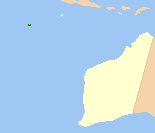
 Location of the coast of Western Australia | |
 | |
| Population | 593 (LGA 2021)[1] |
| Area | 14.1 km2 (5.4 sq mi) |
| Mayor | Aindil Minkom (shire president) |
| Council seat | Home Island |
| Region | External territory of Australia |
| Federal division(s) | Lingiari |
 | |
| Website | Shire of Cocos (Keeling) Islands |
The Shire of Cocos (Keeling) Islands is a local government area which manages local affairs on the Australian external territory of Cocos (Keeling) Islands (12°07′S 96°54′E / 12.117°S 96.900°E; post code: 6799). The island is grouped with Western Australia but is administered by the Department of Infrastructure, Regional Development and Cities[2] and an Administrator.
The Shire covers an area of 14.1 km2 (5.4 sq mi) in the Indian Ocean, about 2,770 km (1,720 mi) north-west of Perth and 1,000 km (620 mi) south-west of Java in Indonesia. The current shire president is Aindil Minkom, who was elected in October 2019.
- ^ Australian Bureau of Statistics (28 June 2022). "Cocos Islands (Local Government Area)". Australian Census 2021 QuickStats. Retrieved 28 June 2022.
- ^ "Territories of Australia". Department of Infrastructure, Regional Development and Cities. 30 January 2008. Retrieved 7 December 2018.
The Australian Government, through the Department of Infrastructure, Regional Development and Cities administers the Ashmore and Cartier Islands, Christmas Island, the Cocos (Keeling) Islands, the Coral Sea Islands, the Jervis Bay Territory and Norfolk Island. The department also manages the Government's interests in the Australian Capital Territory, and the Northern Territory.