| Shire of Esk Queensland | |||||||||||||||
|---|---|---|---|---|---|---|---|---|---|---|---|---|---|---|---|
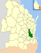
 Location within Queensland | |||||||||||||||
| Population | 15,002 (2006 census)[1] | ||||||||||||||
| • Density | 3.81119/km2 (9.8709/sq mi) | ||||||||||||||
| Established | 1879 | ||||||||||||||
| Abolished | 2007 | ||||||||||||||
| Area | 3,936.3 km2 (1,519.8 sq mi) | ||||||||||||||
| Council seat | Esk | ||||||||||||||
| Region | South East Queensland | ||||||||||||||
 | |||||||||||||||
| Website | Shire of Esk | ||||||||||||||
| |||||||||||||||
The Shire of Esk was a local government area in South East Queensland, Australia, located about 90 kilometres (56 mi) west - northwest of Brisbane. It stretched from the Lockyer Valley north and west to the Great Dividing Range and up the valley of the Brisbane River. Esk covered an area of 3,936.2 square kilometres (1,519.8 sq mi), and existed from 1879 until its merger with the Shire of Kilcoy to form the Somerset Region on 15 March 2008.
- ^ Australian Bureau of Statistics (25 October 2007). "Esk (S) (Local Government Area)". 2006 Census QuickStats. Retrieved 18 March 2008.