| Shire of Murchison Western Australia | |||||||||||||||
|---|---|---|---|---|---|---|---|---|---|---|---|---|---|---|---|
 The Murchison Shire offices | |||||||||||||||
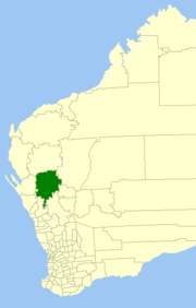
 Location in Western Australia | |||||||||||||||
 | |||||||||||||||
| Population | 101 (LGA 2021)[1] | ||||||||||||||
| Established | 1875 | ||||||||||||||
| Area | 49,500 km2 (19,112.1 sq mi) | ||||||||||||||
| Shire President | Ross Foulkes-Taylor | ||||||||||||||
| Council seat | Murchison Settlement | ||||||||||||||
| Region | Mid West | ||||||||||||||
| State electorate(s) | North West | ||||||||||||||
| Federal division(s) | Durack | ||||||||||||||
 | |||||||||||||||
| Website | Shire of Murchison | ||||||||||||||
| |||||||||||||||
| |||||||||||||||
The Shire of Murchison is a 49,500 km² local government area (LGA), within the Murchison sub-region, in the Mid West region of Western Australia. Encompassing most of the Murchison and East Murchison goldfields, the shire is named after the Murchison River. It is Australia's least-populated LGA and the only one without an official town.[3][4][5] Five sparsely-populated rural localities, with a collective population of 101 (as of 2021), comprise the entire shire. The shire offices, located 300 kilometres (186 mi) northeast of Geraldton, are the focal point of Murchison Settlement, a small part of the Murchison locality.
- ^ Australian Bureau of Statistics (28 June 2022). "Murchison (Local Government Area)". Australian Census 2021 QuickStats. Retrieved 28 June 2022.
- ^ a b c "Summary statistics Murchison". Climate statistics for Australian locations. Bureau of Meteorology. Retrieved 26 February 2020.
- ^ SMH Travel (8 February 2004). "Murchison – a vast shire without a town". The Sydney Morning Herald. Retrieved 22 December 2006.
- ^ 3218.0 – Regional Population Growth, Australia, 2006–07 — 3218.0 Population Estimates by Statistical Local Area, 2001 to 2007. Australian Bureau of Statistics.
- ^ "Annual Report for the year ending 30 June 2015" (PDF). Shire of Murchison, Western Australia. 17 December 2015. Retrieved 29 December 2015.