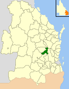
| Shire of Nanango Queensland | |||||||||||||||
|---|---|---|---|---|---|---|---|---|---|---|---|---|---|---|---|
 Location within Queensland | |||||||||||||||
| Population | 9,049 (2006 census)[1] | ||||||||||||||
| • Density | 5.2054/km2 (13.4818/sq mi) | ||||||||||||||
| Established | 1879 | ||||||||||||||
| Area | 1,738.4 km2 (671.2 sq mi) | ||||||||||||||
| Council seat | Nanango | ||||||||||||||
| Region | South Burnett | ||||||||||||||
| Website | Shire of Nanango | ||||||||||||||
| |||||||||||||||
The Shire of Nanango was a local government area located in the South Burnett region of Queensland, Australia, about 100 kilometres (62 mi) northwest of the capital, Brisbane. The Shire covered an area of 1,738.4 square kilometres (671.2 sq mi), and existed as a local government entity from 1879 until 2008, when it amalgamated with several other councils in the South Burnett area to become the South Burnett Regional Council.
- ^ Australian Bureau of Statistics (25 October 2007). "Nanango (S) (Local Government Area)". 2006 Census QuickStats. Retrieved 18 March 2008.