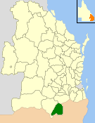
| Shire of Stanthorpe Queensland | |||||||||||||||
|---|---|---|---|---|---|---|---|---|---|---|---|---|---|---|---|
 Location within Queensland | |||||||||||||||
| Population | 9,968 (2006 census)[1] | ||||||||||||||
| • Density | 3.69514/km2 (9.5704/sq mi) | ||||||||||||||
| Established | 1879 | ||||||||||||||
| Area | 2,697.6 km2 (1,041.5 sq mi) | ||||||||||||||
| Council seat | Stanthorpe | ||||||||||||||
| Region | Darling Downs | ||||||||||||||
 | |||||||||||||||
The Shire of Stanthorpe was a local government area of Queensland, Australia on the Queensland-New South Wales border. It was on the Great Dividing Range and was part of the Granite Belt. Its main industries included fruit and vegetable growing, wineries and tourism, and sheep and cattle grazing.
The Shire, administered from the town of Stanthorpe, covered an area of 2,697.6 square kilometres (1,041.5 sq mi), and existed from 1879 until 2008, when it amalgamated with the Shire of Warwick to become the Southern Downs Region. Its final mayor was Glen Rogers.
- ^ Australian Bureau of Statistics (25 October 2007). "Stanthorpe (S) (Local Government Area)". 2006 Census QuickStats. Retrieved 18 September 2009.