| Shire of Taroom Queensland | |||||||||||||||
|---|---|---|---|---|---|---|---|---|---|---|---|---|---|---|---|
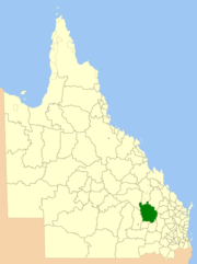
 Location within Queensland | |||||||||||||||
| Population | 2,389 (2006 census)[1] | ||||||||||||||
| • Density | 0.128134/km2 (0.33187/sq mi) | ||||||||||||||
| Established | 1879 | ||||||||||||||
| Area | 18,644.5 km2 (7,198.7 sq mi) | ||||||||||||||
| Council seat | Taroom | ||||||||||||||
| Region | Darling Downs | ||||||||||||||
 | |||||||||||||||
| Website | Shire of Taroom | ||||||||||||||
| |||||||||||||||
The Shire of Taroom was a local government area in the Darling Downs region of Queensland, Australia, along the Leichhardt Highway to the north of Miles. The shire covered an area of 18,644.5 square kilometres (7,198.7 sq mi), and existed as a local government area from 1879 until 2008, when it was dissolved and split between the new Western Downs Region and the Shire of Banana.
The shire contained several national parks with eroded sandstone areas, as well as Isla Gorge.
- ^ Australian Bureau of Statistics (25 October 2007). "Taroom (S) (Local Government Area)". 2006 Census QuickStats. Retrieved 17 June 2011.