Short Creek Township, Harrison County, Ohio | |
|---|---|
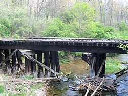
 This old bridge across South Branch Short Creek next to U.S. Route 250 led to the Georgetown Mine. | |
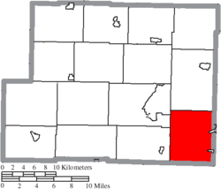
 Location of Short Creek Township in Harrison County | |
| Coordinates: 40°12′33″N 80°54′38″W / 40.20917°N 80.91056°W | |
| Country | United States |
| State | Ohio |
| County | Harrison |
| Area | |
• Total | 30.6 sq mi (79.3 km2) |
| • Land | 30.1 sq mi (78.0 km2) |
| • Water | 0.5 sq mi (1.3 km2) |
| Elevation | 945 ft (288 m) |
| Population | |
• Total | 1,031 |
| • Density | 34/sq mi (13/km2) |
| Time zone | UTC-5 (Eastern (EST)) |
| • Summer (DST) | UTC-4 (EDT) |
| ZIP code | 43907 |
| Area code | 740 |
| FIPS code | 39-72361[3] |
| GNIS feature ID | 1086283[1] |
Short Creek Township is one of the fifteen townships of Harrison County, Ohio, United States. As of the 2020 census the population was 1,031.
- ^ a b "US Board on Geographic Names". United States Geological Survey. October 25, 2007. Retrieved January 31, 2008.
- ^ "Short Creek township, Harrison County, Ohio - Census Bureau Profile". United States Census Bureau. Retrieved July 10, 2023.
- ^ "U.S. Census website". United States Census Bureau. Retrieved January 31, 2008.