| Shotover River Kimiākau | |
|---|---|
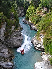
 Jet boating the Shotover River canyons | |
 | |
| Etymology | After Shotover Park in Oxfordshire. |
| Native name | Kimiākau (Māori) |
| Location | |
| Country | New Zealand |
| Physical characteristics | |
| Mouth | |
• location | Kawarau River |
• elevation | 290 m (950 ft) |
| Length | 75 km (47 mi) |

The Shotover River (Māori: Kimiākau) is located in the Otago region of the South Island of New Zealand.[1] The name correctly suggests that this 75-kilometre (47 mi) long river is fast flowing, with numerous rapids. The river flows generally south from the Southern Alps on its journey running through the Skippers Canyon, draining the area between the Richardson Mountains and the Harris Mountains, before flowing into the Kawarau River east of Queenstown.
The Edith Cavell bridge crosses the river at Arthurs Point.
- ^ "Place name detail: Shotover River". New Zealand Gazetteer. New Zealand Geographic Board. Retrieved 2009-02-02.