| Shuswap Lake | |
|---|---|
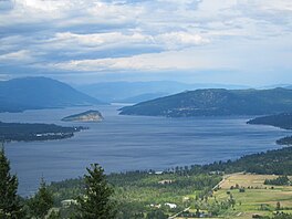
 Western reaches of Shuswap Lake | |
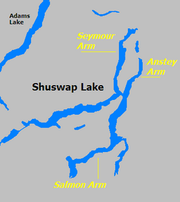
 The three arms of Shuswap Lake | |
| Location | South-Central British Columbia |
| Coordinates | 50°59′N 119°1′W / 50.983°N 119.017°W |
| Primary inflows | Adams River, Scotch Creek, Seymour River, Anstey River, Eagle River, Shuswap River (via Mara Lake/Sicamous Narrows), Salmon River |
| Primary outflows | Little River |
| Basin countries | Canada |
| Max. length | 89 km (55 mi) |
| Max. width | 5 km (3.1 mi) |
| Surface area | 310 km2 (120 sq mi) |
| Average depth | 61.6 m (202 ft) |
| Max. depth | 161 m (528 ft) |
| Water volume | 19.1 km3 (4.6 cu mi) |
| Residence time | 2.1 years |
| Surface elevation | 347 m (1,138 ft) |
| Islands | Copper |
| Settlements | (see article) |
Shuswap Lake (pronounced /ˈʃuːʃwɑːp/) is a lake located in the southern interior of British Columbia, Canada that drains via the Little Shuswap River into Little Shuswap Lake. Little Shuswap Lake is the source of the South Thompson River, a branch of the Thompson River, a tributary of the Fraser River. It is at the heart of a region known as the Columbia Shuswap or "the Shuswap", noted for its recreational lakeshore communities including the city of Salmon Arm. The name "Shuswap" is derived from the Shuswap or Secwepemc First Nations people, the most northern of the Interior Salish peoples, whose territory includes the Shuswap. The Shuswap call themselves /ʃǝxwépmǝx/ in their own language, which is called /ʃǝxwepmǝxtʃín/.[1]
- ^ William J. Poser. "The Names of the First Nations Languages of British Columbia" (PDF). Billposer.org. Retrieved 21 May 2018.
