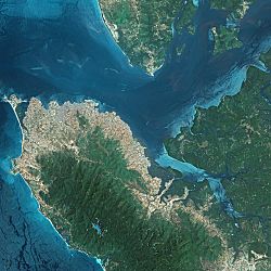
| Sierra Leone River | |
|---|---|
 Sierra Leone River Estuary | |
| Physical characteristics | |
| Mouth | |
• location | Atlantic Ocean |
• coordinates | 8°30′14″N 13°11′10″W / 8.504°N 13.186°W |
| Length | 25 mi (40 km) |
| Official name | Sierra Leone River Estuary |
| Designated | 13 December 1999 |
| Reference no. | 1014[1] |
The Sierra Leone River is a river estuary on the Atlantic Ocean in Western Sierra Leone. It is formed by the Bankasoka River and Rokel River and is between 4 and 10 miles wide (6–16 km) and 25 miles (40 km) long. It holds the major ports of Queen Elizabeth II Quay and Pepel. The estuary is also important for shipping. It is the largest natural harbour in the African continent. Several islands, including Tasso Island (the largest), Tombo Island, and the historically important Bunce Island, are located in the estuary.[2]
- ^ "Sierra Leone River Estuary". Ramsar Sites Information Service. Retrieved 25 April 2018.
- ^ "Sierra Leone River" britannica.com