| Sierra Pandura | |
|---|---|
| Cuchilla de Pandura, La Pica | |
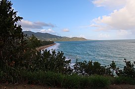
 Eastern end of Sierra Pandura from Punta Tuna. | |
| Highest point | |
| Peak | Cerro Santa Elena |
| Elevation | 1,722 ft (525 m) |
| Geography | |
 | |
| Location | Maunabo and Yabucoa, Puerto Rico |
| Parent range | Cordillera Central |
Sierra Pandura, also known as Cuchilla de Pandura (Pandura Ridge) and La Pica, is a mountain range that runs from the Sierra de Cayey in the northwest to the Caribbean Sea in the southeast in southeastern Puerto Rico, between the municipalities of Maunabo and Yabucoa. Together with the Sierra de Guardarraya to the south, Sierra Pandura is part of the San Lorinzo batholith physiological region, a composite body of volcanic origin which bifurcates the mountain ridge.[1]
Sierra Pandura rises to an elevation of 1,722 feet (525 m) above sea level at Cerro Santa Elena, located in the barrio Juan Martín of Yabucoa. Other peaks in the mountain range include Cerro de la Pandura, located near the sector of La Pica with an elevation of 1,692 feet (516 m) above sea level, and El Sombrerito (Spanish for "the little hat") with 1,463 feet (446 m) in elevation.[2][3]
- ^ "Sierra Pandura". Para la Naturaleza. 2013-05-08. Retrieved 2022-01-25.
- ^ "Cerro Santa Elena". PeakVisor. Retrieved 2022-01-25.
- ^ "Yabucoa Mountains". PeakVisor. Retrieved 2022-01-25.