| Signal Hill | |
|---|---|
 | |
| Location | St. John's, Newfoundland and Labrador, Canada |
| Coordinates | 47°34′25″N 52°41′01″W / 47.57361°N 52.68361°W[1] |
| Governing body | Parks Canada |
| Website | Signal Hill National Historic Site |
| Signal Hill | |
|---|---|
 | |
| Highest point | |
| Elevation | 167 m (548 ft) |
| Prominence | c. 167 m (548 ft) |
| Geography | |
| Location | St. John's |
| Climbing | |
| Easiest route | hillwalking |
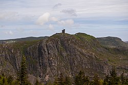
Signal Hill is a hill which overlooks the harbour and city of St. John's, Newfoundland and Labrador, Canada. The majority of Signal Hill, including Cabot Tower, is designated a National Historic Site. The highest point, Ladies' Lookout, is 167 m (548 ft) high.
Due to its strategic placement overlooking the Narrows, the only entrance to the harbour, fortifications date back to the mid 17th century. On 12 December 1901, the first transatlantic wireless transmission was received there by Guglielmo Marconi.
Adjacent to the National Historic site is the Johnson Geo Centre and Johnson Geo Vista Park. The community of The Battery lies on the slope of the hill overlooking the harbour, and Memorial University of Newfoundland has a campus on the lower slopes, in the former Battery Hotel.