| Silver Sands Mandurah, Western Australia | |||||||||||||||
|---|---|---|---|---|---|---|---|---|---|---|---|---|---|---|---|
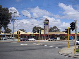
 Silver Sands near Mandurah | |||||||||||||||
 | |||||||||||||||
| Coordinates | 32°30′43″S 115°44′06″E / 32.512°S 115.735°E | ||||||||||||||
| Population | 1,451 (SAL 2021)[1] | ||||||||||||||
| Established | 1989 | ||||||||||||||
| Postcode(s) | 6210 | ||||||||||||||
| Area | 1.4 km2 (0.54 sq mi) | ||||||||||||||
| LGA(s) | City of Mandurah | ||||||||||||||
| State electorate(s) | Mandurah | ||||||||||||||
| Federal division(s) | Canning | ||||||||||||||
| |||||||||||||||
Silver Sands is an inner northern coastal suburb of Mandurah, Western Australia.
The suburb, along with neighbouring San Remo, were gazetted in 1989. Both suburbs were named after developer estates, which entered into popular local usage.
- ^ Australian Bureau of Statistics (28 June 2022). "Silver Sands (suburb and locality)". Australian Census 2021 QuickStats. Retrieved 28 June 2022.