Silverthorn | |
|---|---|
Neighbourhood | |
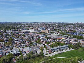
 Aerial view of Silverthorn from Harwood, York in 2024 | |
 Vicinity | |
| Coordinates: 43°41′24″N 79°28′34″W / 43.690°N 79.476°W | |
| Country | |
| Province | |
| City | Toronto |
| Established | 1850 (York Township) |
| Changed municipality | 1998 Toronto from York |
| Government | |
| • MP | Ahmed Hussen (York South—Weston) |
| • MPP | Michael Ford (York South—Weston) |
| • Councillor | Frances Nunziata (Ward 5 York South—Weston) |
Silverthorn, often misspelled as Silverthorne, is a neighbourhood and former postal village in Toronto, Ontario, Canada. The approximate boundaries are the GO Transit Barrie line railway tracks to the east, Black Creek Drive and the CP railway line to the west and the former boundaries of the City of York to the north and south. The neighbourhood west of Keele Street is known as Keelesdale. For demographic purposes, the city breaks the area down into two neighbourhoods Keelesdale-Eglinton West, south of Eglinton, and Beechborough-Greenbrook north of Eglinton. It was originally a postal village to serve the then-agricultural York Township.
