| Silverwood Lake | |
|---|---|
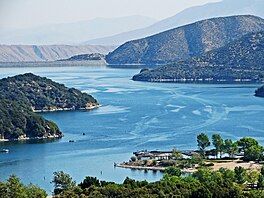
 Looking north, Cedar Springs Dam at top left | |
| Location | San Bernardino County, California |
| Coordinates | 34°18′14″N 117°19′05″W / 34.30389°N 117.31806°W |
| Type | Reservoir |
| Primary inflows | California Aqueduct and West Fork Mojave River, East Fork of West Fork Mojave River and Sawpit Canyon Creek |
| Primary outflows | West Fork Mojave River |
| Basin countries | United States |
| Water volume | 73,000 acre-feet (90×106 m3) |
| Surface elevation | 1,023 m (3,356 ft) |
Silverwood Lake is a large reservoir in San Bernardino County, California, United States, located on the West Fork Mojave River, a tributary of the Mojave River in the San Bernardino Mountains. It was created in 1971 as part of the State Water Project by the construction of the Cedar Springs Dam as a forebay on the 444 mi (715 km) long California Aqueduct (consequently inundating the former town of Cedar Springs[1]), and has a capacity of 73,000 acre⋅ft (90,000,000 m3).[2]
- ^ "Cedar Springs (historical)". Geographic Names Information System. United States Geological Survey, United States Department of the Interior. Retrieved 4 May 2018.
- ^ "Reservoir Information". California Department of Water Resources, Division of Flood Management. 2007-01-25. Archived from the original on 2011-02-23. Retrieved 2007-01-26.
