Simla, Colorado | |
|---|---|
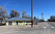
 Looking east along Highway 24 in Simla. | |
 Location of Simla in Elbert County, Colorado. | |
| Coordinates: 39°8′27″N 104°4′58″W / 39.14083°N 104.08278°W | |
| Country | |
| State | |
| County[1] | Elbert County |
| Incorporated | January 15, 1912[3] |
| Government | |
| • Type | Statutory Town[1] |
| Area | |
| • Total | 0.62 sq mi (1.60 km2) |
| • Land | 0.62 sq mi (1.60 km2) |
| • Water | 0.00 sq mi (0.00 km2) |
| Elevation | 5,978 ft (1,822 m) |
| Population (2020) | |
| • Total | 601 [2] |
| • Density | 972.9/sq mi (375.63/km2) |
| Time zone | UTC-7 (MST) |
| • Summer (DST) | UTC-6 (MDT) |
| ZIP code[6] | 80835 |
| Area code | 719 |
| FIPS code | 08-70635 |
| GNIS feature ID | 0193219 |
| Website | townofsimla |
Simla is a statutory town in Elbert County, Colorado, United States. It is 48 miles (77 km) northeast of Colorado Springs. The population was 601 at the time of the 2020 United States Census.
- ^ a b "Active Colorado Municipalities". State of Colorado, Department of Local Affairs. Archived from the original on December 12, 2009. Retrieved September 1, 2007.
- ^ "Explore Census Data".
- ^ "Colorado Municipal Incorporations". State of Colorado, Department of Personnel & Administration, Colorado State Archives. December 1, 2004. Retrieved September 2, 2007.
- ^ "2019 U.S. Gazetteer Files". United States Census Bureau. Retrieved July 1, 2020.
- ^ "US Board on Geographic Names". United States Geological Survey. October 25, 2007. Retrieved January 31, 2008.
- ^ "ZIP Code Lookup" (JavaScript/HTML). United States Postal Service. Retrieved January 3, 2008.