Singtam | |
|---|---|
Town | |
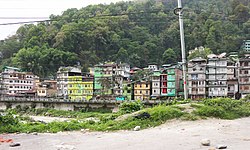
 View of Singtam | |
| Coordinates: 27°13′59″N 88°29′46″E / 27.2331°N 88.4961°E | |
| Country | |
| State | |
| District | |
| Government | |
| • Type | Nagar Panchayat |
| • Body | Singtam Municipal Council |
| Elevation | 426 m (1,396 ft) |
| Population (2011) | |
| • Total | 5,868 |
| Languages | |
| • Official | Nepali, Bhutia, Lepcha, Limbu, Newari, Rai, Gurung, Mangar, Sherpa, Tamang and Sunwar |
| Time zone | UTC+5:30 (IST) |
| PIN | 737 134 |
| Telephone code | 03592 |
| Vehicle registration | SK 08 |
| Literacy | 86.08% |
| Lok Sabha | Sikkim Constituency |
| Vidhan Sabha | Khamdong-Singtam Constituency |
| Website | eastsikkim |
Singtam is a town which lies mostly in Gangtok District and partly in Pakyong District in the Indian state of Sikkim about 30 kilometres (19 mi) from the state capital Gangtok. The town lies on the banking of the rivers Teesta and Ranikhola, which join together just below the town. NH10 and NH510 meet in Singtam. The Indreni Bridge and Sherwani Bridge over the river Teesta are in the town. Singtam District Hospital, the district hospital of Pakyong District,[1] lies at Golitar, Singtam.
- ^ "3 sub-divisions of East Sikkim to form Sikkim's newest district Pakyong -Eastmojo". eastmojo.com. 21 June 2021.

