| Sinks Canyon State Park | |
|---|---|
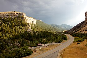
 Looking west from the entrance of the canyon | |
| Location | Fremont County, Wyoming, United States |
| Nearest city | Lander |
| Coordinates | 42°43′22″N 108°52′30″W / 42.72278°N 108.87500°W[1] |
| Area | 600 acres (240 ha)[2] |
| Elevation | 6,122 ft (1,866 m)[1] |
| Established | 1971 |
| Administered by | Wyoming State Parks, Historic Sites & Trails |
| Designation | Wyoming state park |
| Website | Official website |
Sinks Canyon State Park is a public recreation and nature preservation area located in the Wind River Mountains, six miles (9.7 km) southwest of Lander, Wyoming, on Wyoming Highway 131. The state park is named for a portion of the Middle Fork of the Popo Agie River where it flows into an underground limestone cavern, named "the Sinks," and emerges a quarter-mile down the canyon in a pool named "the Rise." The park is managed by the Wyoming Division of State Parks and Historic Sites.[3]
- ^ a b "Sinks Canyon". Geographic Names Information System. United States Geological Survey, United States Department of the Interior.
- ^ Cite error: The named reference
soar2021was invoked but never defined (see the help page). - ^ Cite error: The named reference
parkwas invoked but never defined (see the help page).
