Sint-Pieters-Leeuw
Leeuw-Saint-Pierre (French) | |
|---|---|
 | |
| Coordinates: 50°47′N 04°15′E / 50.783°N 4.250°E | |
| Country | |
| Community | Flemish Community |
| Region | Flemish Region |
| Province | Flemish Brabant |
| Arrondissement | Halle-Vilvoorde |
| Government | |
| • Mayor | Jan Desmeth (N-VA) |
| • Governing party/ies | N-VA, CD&V |
| Area | |
• Total | 40.67 km2 (15.70 sq mi) |
| Population (2018-01-01)[1] | |
• Total | 34,038 |
| • Density | 840/km2 (2,200/sq mi) |
| Postal codes | 1600-1602 |
| NIS code | 23077 |
| Area codes | 02 |
| Website | www.sint-pieters-leeuw.be |
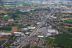
Sint-Pieters-Leeuw (Dutch pronunciation: [sɪnt ˌpitərs ˈleːu]; French: Leeuw-Saint-Pierre, pronounced [lø sɛ̃ pjɛʁ]) is a municipality in the province of Flemish Brabant, in the Flemish region of Belgium.
The municipality comprises the towns of Oudenaken, Ruisbroek, Sint-Laureins-Berchem, Sint-Pieters-Leeuw proper and Vlezenbeek. Sint-Pieters-Leeuw is located just outside the Brussels-Capital Region, in the Payottenland. The municipality is a blend of parks, castles, meadows and gardens with the Coloma park as its green heart.
On 1 January 2018, Sint-Pieters-Leeuw had a total population of 34,025. The total area is 40.38 km2 (15.59 sq mi), which gives a population density of 842/km2 (2,180/sq mi). It is a mostly a residential community with largely preserved rural areas and some industrial zones.[2] The official language of Sint-Pieters-Leeuw is Dutch.
- ^ "Wettelijke Bevolking per gemeente op 1 januari 2018". Statbel. Retrieved 9 March 2019.
- ^ Bevolkingscijfers Sint-Pieters-Leeuw


