| Sirikit Dam | |
|---|---|
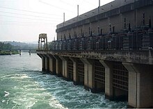
 The dam's power station at its base | |
| Official name | Queen Sirikit Dam |
| Country | Thailand |
| Location | Tha Pla, Uttaradit |
| Coordinates | 17°45′50″N 100°33′48″E / 17.76389°N 100.56333°E |
| Status | In use |
| Construction began | 1968 |
| Opening date | 1974 |
| Owner(s) | Electricity Generating Authority of Thailand |
| Dam and spillways | |
| Type of dam | Embankment |
| Impounds | Nan River |
| Height | 113.6 m (373 ft) |
| Length | 800 m (2,625 ft) |
| Width (crest) | 12 m (39 ft) |
| Width (base) | 630 m (2,067 ft) |
| Spillway type | Tunnel, service |
| Spillway capacity | 3,250 m3/s (114,773 cu ft/s) |
| Reservoir | |
| Creates | Sirikit Reservoir |
| Total capacity | 9,510,000,000 m3 (7,709,882 acre⋅ft) |
| Active capacity | 6,668,000,000 m3 (5,405,836 acre⋅ft) |
| Catchment area | 13,130 km2 (5,070 sq mi) |
| Surface area | 259 km2 (100 sq mi) |
| Power Station | |
| Commission date | 1974, 1995 |
| Hydraulic head | 75.4 m (247 ft) (rated) |
| Turbines | 4 x 125 MW Francis-type |
| Installed capacity | 500 MW |
The Queen Sirikit Dam is an embankment dam on the Nan River, a tributary of the Chao Phraya River, in Tha Pla District, Uttaradit Province, Thailand. It is at the southeastern edge of the Phi Pan Nam Range. The dam was built for the purpose of irrigation, flood control and hydroelectric power production. It is named after Sirikit, Queen of Thailand.[1]
