| Sirmilik National Park | |
|---|---|
| Parc national Sirmilik | |
 | |
Location of the park in Baffin Island, Canada | |
| Location | Nunavut, Canada |
| Nearest city | Pond Inlet |
| Coordinates | 72°59′26″N 81°08′14″W / 72.9906°N 81.13732°W |
| Area | 22,200 km2 (8,600 sq mi) |
| Established | 2001[1] |
| Visitors | 6 (in 2022–23[2]) |
| Governing body | Parks Canada |
| www | |
 | |
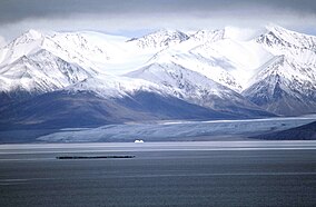
Sirmilik National Park (/ˈsɜːrməlɪk/; Inuktitut: "the place of glaciers"[3]) is a national park located in Qikiqtaaluk, Nunavut, Canada, established in 1999.[4][5][6] Situated within the Arctic Cordillera, the park is composed of three areas: most of Bylot Island with the exception for a few areas that are Inuit-owned lands, Kangiqłuruluk, and Baffin Island's Borden Peninsula.[4][7] Much of the park is bordered by water.
Geographically, it is representative of the Northern Eastern Arctic Lowlands Natural Region as well as parts of the Lancaster Sound Marine Region.[4]
- ^ "Ecological Studies and Environmental Monitoring at Bylot Island, Sirmilik National Park". Cen.ulaval.ca. Archived from the original on 2010-04-11. Retrieved 2010-09-20.
- ^ Canada, Parks. "Parks Canada attendance 2022_23 - Parks Canada attendance 2022_23 - Open Government Portal". open.canada.ca. Retrieved 2024-05-07.
- ^ "Sirmilik National Park". The Canadian Encyclopedia. Archived from the original on February 4, 2013. Retrieved 2013-06-22.
- ^ a b c "Sirmilik National Park of Canada". Parks Canada. Retrieved 22 June 2013.
- ^ "Sirmilik National Park, Canada". National Aeronautics and Space Administration. 2008-10-14. Archived from the original on 2022-10-16. Retrieved 20 September 2010.
- ^ National Geographic Guide to the National Parks of Canada Second Edition. National Geographic. 2016. pp. 368–373. ISBN 978-1-4262-1756-2.
- ^ "Study Site". University of Laval. Archived from the original on 11 April 2010. Retrieved 20 September 2010.

