Siskiyou County, California | |
|---|---|
| County of Siskiyou | |
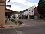
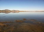
Images, from top down, left to right: Mount Shasta, the historic West Miner Street in Yreka, Indian Tom Lake, Captain Jack's Stronghold in the Lava Beds National Monument, the McCloud River | |
| Motto: "Mountains of Opportunity" | |
 Interactive map of Siskiyou County | |
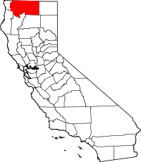
 Location in the state of California | |
| Coordinates: 41°35′N 122°30′W / 41.583°N 122.500°W | |
| Country | United States |
| State | California |
| Region | Shasta Cascade |
| Incorporated | March 22, 1852 |
| Named for | The Siskiyou Trail |
| County seat | Yreka |
| Largest city | Yreka |
| Government | |
| • Type | Council–Administrator |
| • Chair | Ed Valenzuela |
| • Vice Chair | Michael N. Kobseff |
| • Board of Supervisors[1] | Supervisors
|
| • County Administrator | Terry Barber |
| Area | |
• Total | 6,347 sq mi (16,440 km2) |
| • Land | 6,278 sq mi (16,260 km2) |
| • Water | 69 sq mi (180 km2) |
| Highest elevation | 14,162 ft (4,317 m) |
| Population | |
• Total | 44,076 |
| • Density | 6.9/sq mi (2.7/km2) |
| GDP | |
| • Total | $2.008 billion (2022) |
| Time zone | UTC−8 (Pacific Time Zone) |
| • Summer (DST) | UTC−7 (Pacific Daylight Time) |
| Area code | 530 |
| FIPS code | 06-093 |
| GNIS feature ID | 277311 |
| Congressional district | 1st |
| Website | co |
Siskiyou County (/ˈsɪskjuː/ SISK-yoo) is a county located in the northwestern part of the U.S. state of California. As of the 2020 census, the population was 44,076.[3] Its county seat is Yreka and its highest point is Mount Shasta.[5] It falls within the Cascadia bioregion.[6]
Siskiyou County is in the Shasta Cascade region along the Oregon border. Because of its outdoor recreation, Mt. Shasta, McCloud River, and Gold Rush-era history, it is an important tourist destination within the state.[citation needed]
- ^ "Board of Supervisors | Siskiyou County California". www.co.siskiyou.ca.us.
- ^ "Mount Shasta". Peakbagger.com. Retrieved February 2, 2015.
- ^ a b "State & County QuickFacts". United States Census Bureau. Retrieved December 6, 2021.
- ^ "Gross Domestic Product: All Industries in Siskiyou County, CA". Federal Reserve Economic Data. Federal Reserve Bank of St. Louis.
- ^ "Find a County". National Association of Counties. Retrieved June 7, 2011.
- ^ "Boundaries". Cascadia Institute. Retrieved August 27, 2021.


