Sivasagar district | |
|---|---|
|
From top, left to right: Sivasagar Sivadol, Talatal Ghar, Kareng Ghar, Joy dol, Rang Ghar,Sivasagar Tank (Borpukhuri) | |
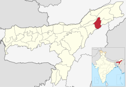
 Location in Assam | |
| Country | India |
| State | Assam |
| Division | Upper Assam |
| Headquarters | Sivasagar |
| Tehsils | 1. Amguri 2. Gaurisagar 3. Sivasagar 4. Demow 5. Nazira 6. Lakowa |
| Government | |
| • Lok Sabha constituencies | 1. Jorhat |
| • Vidhan Sabha constituencies | Amguri, Nazira, Thowra, Sibsagar |
| Area | |
• Total | 1,599 km2 (617 sq mi) |
| Population (2011) | |
• Total | 679,632 |
| • Density | 430/km2 (1,100/sq mi) |
| Demographics | |
| • Literacy | 81.36% |
| • Sex ratio | 951 per 1000 male |
| Time zone | UTC+05:30 (IST) |
| Major highways | NH-37 |
| Website | sivasagar |
Sivasagar district (Pron: /ˈsɪvəˌsʌɡər/ or /ˈʃɪvəˌsʌɡər/), formerly known as Sibsagar, is one of the 34 districts of Assam state in Northeast India. Sivasagar city is the administrative headquarters of this district. This historic place is also known for its rich biodiversity.[1] The districts covers an area of 2668 square kilometers (of the total area of 78438 square kilometers of Assam). The district comprises two sub-divisions – Sivasagar and Nazira. The district of Sivasagar lies between 26.45°N and 27.15°N latitudes and 94.25°E and 95.25°E longitudes. The district is bounded by the Brahmaputra River to the north, Nagaland to the south, the Charaideo district to the east and the Jhanji River to the west. The Sivasagar district has acquired its distinct identity due to the co-existence of different races, tribes, languages and cultures.
- ^ District at a glance, Sivasagar. Office of the Deputy Director of Economics and Statistics, Sivasagar. 2001.


