Six Mile, South Carolina | |
|---|---|
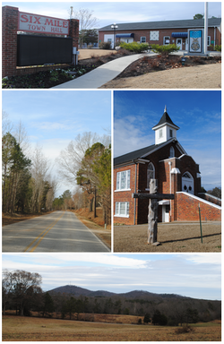
 Top, left to right: Six Mile Town Hall, Liberty Highway, Six Mile Baptist Church, view of nearby mountain from Main Street | |
 Location of Six Mile, South Carolina | |
| Coordinates: 34°48′7″N 82°49′4″W / 34.80194°N 82.81778°W | |
| Country | United States |
| State | South Carolina |
| County | Pickens |
| Area | |
| • Total | 2.05 sq mi (5.31 km2) |
| • Land | 2.04 sq mi (5.28 km2) |
| • Water | 0.01 sq mi (0.03 km2) |
| Elevation | 1,024 ft (312 m) |
| Population | |
| • Total | 759 |
| • Density | 372.42/sq mi (143.81/km2) |
| Time zone | UTC−5 (Eastern (EST)) |
| • Summer (DST) | UTC−4 (EDT) |
| ZIP Code | 29682 |
| Area codes | 864, 821 |
| FIPS code | 45-66760[3] |
| GNIS feature ID | 1226654[4] |
| Website | www.sixmilesc.org |
Six Mile is a town in Pickens County, South Carolina, United States. The 2010 census showed a population of 675, representing a 21% increase since 2000. The 2020 census showed a population of 678 representing a 0.30% increase since 2010. The average household income in Six Mile is $82,828 with a poverty rate at 6.54%. The median rental costs in recent years is $618 per month, and the median house value is $258,700
Six Mile was named "Six Mile" because it was located six miles from Fort Prince George. Many other landmarks in this area were named by their distance from Fort Prince George such as 12 Mile River, 18 Mile Creek, and Ninety Six.[5]
- ^ "ArcGIS REST Services Directory". United States Census Bureau. Retrieved October 15, 2022.
- ^ Cite error: The named reference
USCensusDecennial2020CenPopScriptOnlywas invoked but never defined (see the help page). - ^ "U.S. Census website". United States Census Bureau. Retrieved January 31, 2008.
- ^ "US Board on Geographic Names". United States Geological Survey. October 25, 2007. Retrieved January 31, 2008.
- ^ "History & Climate". The Town of Six Mile. Retrieved December 8, 2012.