| Skeena River | |
|---|---|
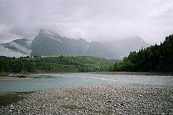
 The Bulkley River (left) flowing into the Skeena River (right) near Hazelton | |
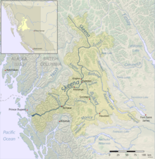
 Skeena River watershed with tributaries | |
| Location | |
| Country | Canada |
| Province | British Columbia |
| City | Terrace |
| Physical characteristics | |
| Source | Spatsizi Plateau |
| • coordinates | 57°9′6″N 128°41′29″W / 57.15167°N 128.69139°W |
| Mouth | Pacific Ocean |
• location | Chatham Sound |
• coordinates | 54°8′15″N 130°5′40″W / 54.13750°N 130.09444°W[1] |
• elevation | 0 m (0 ft) |
| Length | 570 km (350 mi) |
| Basin size | 54,400 km2 (21,000 sq mi)[2] |
| Discharge | |
| • location | mouth[2] |
| • average | 1,760 m3/s (62,000 cu ft/s)[2] |
| Basin features | |
| Tributaries | |
| • left | Sustut River, Babine River, Bulkley River, Zymoetz River |
| • right | Kitwanga River, Lorne Creek, Kitsumkalum River |
The Skeena River is the second-longest river entirely within British Columbia, Canada[3] (after the Fraser River). Since ancient times, the Skeena has been an important transportation artery, particularly for the Tsimshian and the Gitxsan—whose names mean "inside the River of Mist", and "people of the River of Mist," respectively. The river and its basin sustain a wide variety of fish, wildlife, and vegetation, and communities native to the area depend on the health of the river. The Tsimshian migrated to the Lower Skeena River, and the Gitxsan occupy territory of the Upper Skeena.
During the Omineca Gold Rush, steamboat services ran from the sea to Hazelton, which was the jumping-off point for the trails to the goldfields. The Hudson's Bay Company established a major trading post on the Skeena at what became called Port Simpson, British Columbia (Lax Kw'alaams), where nine tribes of the Tsimshian nation settled about 1834. Other tribes live elsewhere in BC, and descendants of one group in Metlakatla, Alaska.
- ^ "Skeena River". BC Geographical Names.
- ^ a b c Cite error: The named reference
BenkeCushing2009was invoked but never defined (see the help page). - ^ British Columbia.com. "Skeena River". Retrieved 2008-01-23.