| Skelton Beck | |
|---|---|
 Skelton Beck flows onto the Beach at Saltburn | |
| Physical characteristics | |
| Source | |
| • location | Tocketts Mill |
| • coordinates | 54°33′11″N 1°01′23″W / 54.553°N 1.023°W |
| • elevation | 57 metres (187 ft) |
| Mouth | |
• location | Saltburn |
• coordinates | 54°35′06″N 0°58′01″W / 54.585°N 0.967°W |
• elevation | 5 metres (16 ft) |
| Length | 23.57 kilometres (14.65 mi) |
| Basin size | 54.11 square kilometres (20.89 sq mi) |
| Basin features | |
| EA waterbody ID | GB103025071970 |
Skelton Beck | |||||||||||||||||||||||||||||||||||||||||||||||||||||||||||||||||||||||||||||||||||||||||||||||||||||||||||||||||||||||||||||||||||||||||||||||||||||||||||||||||||||||||||||||||||||||||||||||||||||||||||
|---|---|---|---|---|---|---|---|---|---|---|---|---|---|---|---|---|---|---|---|---|---|---|---|---|---|---|---|---|---|---|---|---|---|---|---|---|---|---|---|---|---|---|---|---|---|---|---|---|---|---|---|---|---|---|---|---|---|---|---|---|---|---|---|---|---|---|---|---|---|---|---|---|---|---|---|---|---|---|---|---|---|---|---|---|---|---|---|---|---|---|---|---|---|---|---|---|---|---|---|---|---|---|---|---|---|---|---|---|---|---|---|---|---|---|---|---|---|---|---|---|---|---|---|---|---|---|---|---|---|---|---|---|---|---|---|---|---|---|---|---|---|---|---|---|---|---|---|---|---|---|---|---|---|---|---|---|---|---|---|---|---|---|---|---|---|---|---|---|---|---|---|---|---|---|---|---|---|---|---|---|---|---|---|---|---|---|---|---|---|---|---|---|---|---|---|---|---|---|---|---|---|---|---|
| |||||||||||||||||||||||||||||||||||||||||||||||||||||||||||||||||||||||||||||||||||||||||||||||||||||||||||||||||||||||||||||||||||||||||||||||||||||||||||||||||||||||||||||||||||||||||||||||||||||||||||
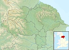
Skelton Beck is a small river in North Yorkshire, England. The beck only runs for 23 kilometres (14 mi) and feeds directly into the North Sea on the south side of Saltburn beach. The beck is noted for occasionally being polluted with wastewater from the abandoned ironstone workings in its headwaters.
