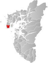
Skudenes Municipality
Skudenes herred | |
|---|---|
 Rogaland within Norway | |
 Skudenes within Rogaland | |
| Coordinates: 59°09′00″N 05°15′23″E / 59.15000°N 5.25639°E | |
| Country | Norway |
| County | Rogaland |
| District | Haugaland |
| Established | 1 Jan 1838 |
| • Created as | Formannskapsdistrikt |
| Disestablished | 1 Jan 1965 |
| • Succeeded by | Karmøy Municipality |
| Administrative centre | Skudeneshavn |
| Area (upon dissolution) | |
| • Total | 68 km2 (26 sq mi) |
| Population (1965) | |
| • Total | 3,583 |
| • Density | 53/km2 (140/sq mi) |
| Demonym | Skudnesbu[1] |
| Time zone | UTC+01:00 (CET) |
| • Summer (DST) | UTC+02:00 (CEST) |
| ISO 3166 code | NO-1150[2] |
Skudenes is a former municipality in Rogaland county, Norway. It was part of the traditional district of Haugaland. The 68-square-kilometre (26 sq mi) municipality[3] existed from 1838 until its dissolution in 1965. The administrative centre was the town of Skudeneshavn (which technically was a separate municipality). The municipality originally encompassed land that is now part of the municipalities of Bokn and Karmøy. It included the southern part of the island of Karmøy and the three islands to the east: Vestre Bokn, Austre Bokn, and Ognøya. In 1849, the three smaller islands were separated to form Bokn municipality.[4]
Today, the Skudenes area refers to the southern part of Karmøy island. In 2009, there were about 3,226 inhabitants.
- ^ "Navn på steder og personer: Innbyggjarnamn" (in Norwegian). Språkrådet.
- ^ Bolstad, Erik; Thorsnæs, Geir, eds. (26 January 2023). "Kommunenummer". Store norske leksikon (in Norwegian). Kunnskapsforlaget.
- ^ Helland, Amund (1888). "Skudenes herred". XI Stavanger amt. Norges land og folk (in Norwegian). Kristiania, Norway: H. Aschehoug & Company. p. 302. Retrieved 3 July 2022.
- ^ Store norske leksikon. "Skudenes" (in Norwegian). Retrieved 29 October 2015.