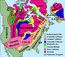

The Slave Craton is an Archaean craton in the north-western Canadian Shield, in Northwest Territories and Nunavut. The Slave Craton includes the 4.03 Ga-old Acasta Gneiss which is one of the oldest dated rocks on Earth.[1][2] Covering about 300,000 km2 (120,000 sq mi), it is a relatively small but well-exposed craton dominated by ~2.73–2.63 Ga (billion years-old) greenstones and turbidite sequences and ~2.72–2.58 Ga plutonic rocks, with large parts of the craton underlain by older gneiss and granitoid units.[3] The Slave Craton is one of the blocks that compose the Precambrian core of North America, also known as the palaeocontinent Laurentia.[4]
The exposed portion of the craton, called the Slave Province, comprises 172,500 km2 (66,600 sq mi) and has an elliptical shape that stretches 680 km (420 mi) NNE from Gros Cap on the Great Slave Lake to Cape Barrow on the Coronation Gulf and 460 km (290 mi) EW along latitude 64°N.[4] It covers about 700 km × 500 km (430 mi × 310 mi) and is bounded by Palaeoproterozoic belts to the south, east, and west, while younger rocks cover it to the north.[5]
The Slave Craton is divided into a west-central basement complex, the Central Slave Basement Complex, and an eastern province, named the Hackett River Terrane or the Eastern Slave Province. These two domains are separated by a 2.7 Ga-old suture defined by two isotopic boundaries running north to south over the craton.[6]
- ^ Stern & Bleeker 1998, Summary
- ^ Bleeker et al. 2004, Basement complex, p. 1
- ^ Bleeker, Stern & Sircombe 2000, Slave Craton and previous investigations, pp. 2–3
- ^ a b Helmstaedt 2009, Geological setting, pp. 1056–1057
- ^ Davis et al. 2003, Geological background
- ^ Jones & Garcia 2006, Geological setting, pp. 126–127