Slavutych
Славутич | |
|---|---|
 One of Slavutych's residential areas | |
| Coordinates: 51°31′14″N 30°45′25″E / 51.52056°N 30.75694°E | |
| Country | |
| Oblast | Kyiv Oblast |
| Raion | Vyshhorod Raion[1] |
| Hromada | Slavutych urban hromada |
| Founded | 1986 |
| City rights | 1986 |
| Government | |
| • Mayor | Yurii Fomichev |
| Area | |
• Total | 2.53 km2 (0.98 sq mi) |
| Population (1 January 2022) | |
• Total | 24,464 |
| • Density | 9,700/km2 (25,000/sq mi) |
| Postal code | 07101 |
| Area code | +380 4579 |
| Website | e-slavutich.gov.ua |
 | |
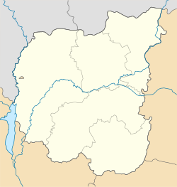
Slavutych (Ukrainian: Славутич, IPA: [slɐˈwutɪtʃ]) is a city and municipality in northern Ukraine, purpose-built for the evacuated personnel of the Chernobyl Nuclear Power Plant after the 1986 disaster that occurred near the city of Pripyat. Geographically located within Chernihiv Raion, Chernihiv Oblast, Slavutych is administratively subordinated to the Kyiv Oblast[1] and is part of Vyshhorod Raion. It is coterminous with Slavutych urban hromada, one of the hromadas of Ukraine.[2] In 2021 the city had a population of 24,464 (2022 estimate).[3]
- ^ a b Where did 354 districts disappear to? Anatomy of loud reform, Glavcom (7 August 2020) (in Ukrainian)
- ^ "Славутичская городская громада". Gromada.info (in Russian). Retrieved 18 June 2022.
- ^ Чисельність наявного населення України на 1 січня 2022 [Number of Present Population of Ukraine, as of January 1, 2022] (PDF) (in Ukrainian and English). Kyiv: State Statistics Service of Ukraine. Archived (PDF) from the original on 4 July 2022.


