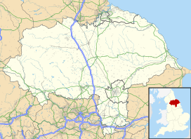
| Sleddale | |
|---|---|
 Sleddale looking northwards | |
| Length | 3 miles (4.8 km) South west–north east [1] |
| Geology | |
| Type | Glacial |
| Geography | |
| Country | England |
| Coordinates | 54°16′N 2°13′W / 54.27°N 2.21°W [2] |
| River | Duerley Beck (Gayle Beck) |
Sleddale is a short, narrow valley to the south of Wensleydale in North Yorkshire, England. The waters draining down the valley feed into the River Ure and form part of the Humber Catchment. The valley has only one settlement, Gayle, although Hawes lies at the mouth of the beck where it runs into the River Ure. The dale is characterised by upland farming and historical mine workings, and is between the slopes of Dodd Fell to the west, and Wether Fell to the east.
- ^ Warren 2001, p. 67.
- ^ "Sleddale, Richmondshire - area information, map, walks and more". getoutside.ordnancesurvey.co.uk. Retrieved 24 February 2024.
