| Sligo Creek | |
|---|---|
 The creek running through Silver Spring, Maryland | |
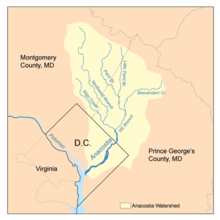
 Map of the Anacostia River watershed showing Sligo Creek | |
| Location | |
| Country | United States |
| State | Maryland |
| City | Silver Spring, Maryland |
| Physical characteristics | |
| Source | |
| • location | Kemp Mill, Maryland |
| • elevation | 450 ft (140 m) |
| Mouth | Northwest Branch |
• location | Hyattsville, Maryland |
• coordinates | 38°57′32″N 76°58′26″W / 38.959°N 76.974°W |
• elevation | 35 ft (11 m) |
| Length | 9.1 mi (14.6 km) |
| Basin size | 11.6 sq mi (30 km2) |
| Discharge | |
| • location | Takoma Park |
| • average | 26 cu ft/s (0.74 m3/s) |
| • minimum | 3.3 cu ft/s (0.093 m3/s) |
| • maximum | 49 cu ft/s (1.4 m3/s) |
| Basin features | |
| Tributaries | |
| • left | Long Branch |
| • right | Wheaton Br, Comstock Br, Takoma Park Br |
Sligo Creek is a free-flowing tributary of the Northwest Branch of the Anacostia River in Maryland. (The Anacostia, in turn, feeds into the Potomac River and eventually empties into the Atlantic Ocean via Chesapeake Bay.) The creek is approximately 9.1 miles (14.6 km) long,[1] with a drainage area of about 11.6 square miles (30 km2).
- ^ "National Hydrography Dataset high-resolution flowline data". The national map. U.S. Geological Survey. Retrieved August 15, 2011.