This article relies largely or entirely on a single source. (February 2014) |
Smolenice | |
|---|---|
Village | |
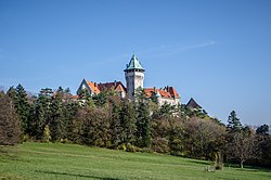
 Smolenice Castle | |
Location of Smolenice in the Trnava Region | |
| Coordinates: 48°30′21″N 17°25′48″E / 48.50583°N 17.43000°E | |
| Country | Slovakia |
| Region | Trnava |
| District | Trnava |
| First mentioned | 1256 |
| Area | |
| • Total | 28.96[2] km2 (11.18[2] sq mi) |
| Elevation | 224[3] m (735[3] ft) |
| Population (2021) | |
| • Total | 3,240[1] |
| Postal code | 919 04[3] |
| Area code | +421 33[3] |
| Car plate | TT |
| Website | www.smolenice.com |
| Source: [5] | |
Smolenice (Hungarian: Szomolány; German: Smolenitz) is a village and municipality of Trnava District in the Trnava Region of Slovakia, on the foothills of the Little Carpathians. It is 60 km northeast of Bratislava and 25 km northwest of Trnava. The village is made of two parts, Smolenice and Smolenická Nová Ves (formerly Neštich).
- ^ "Počet obyvateľov podľa pohlavia - obce (ročne)". www.statistics.sk (in Slovak). Statistical Office of the Slovak Republic. 2022-03-31. Retrieved 2022-03-31.
- ^ a b "Hustota obyvateľstva - obce [om7014rr_ukaz: Rozloha (Štvorcový meter)]". www.statistics.sk (in Slovak). Statistical Office of the Slovak Republic. 2022-03-31. Retrieved 2022-03-31.
- ^ a b c d "Základná charakteristika". www.statistics.sk (in Slovak). Statistical Office of the Slovak Republic. 2015-04-17. Retrieved 2022-03-31.
- ^ a b "Hustota obyvateľstva - obce". www.statistics.sk (in Slovak). Statistical Office of the Slovak Republic. 2022-03-31. Retrieved 2022-03-31.
- ^ Mestská a obecná štatistika SR


