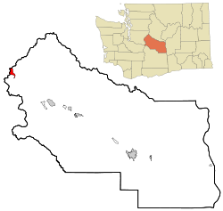
Snoqualmie Pass, Washington | |
|---|---|
 Location of Snoqualmie Pass, Washington | |
| Coordinates: 47°23′32″N 121°24′0″W / 47.39222°N 121.40000°W | |
| Country | United States |
| State | Washington |
| County | Kittitas |
| Area | |
| • Total | 2.93 sq mi (7.58 km2) |
| • Land | 2.93 sq mi (7.58 km2) |
| • Water | 0.0 sq mi (0.0 km2) |
| Elevation | 2,726 ft (831 m) |
| Population | |
| • Total | 372 |
| • Density | 130/sq mi (49/km2) |
| Time zone | UTC-8 (Pacific (PST)) |
| • Summer (DST) | UTC-7 (PDT) |
| ZIP code | 98068 |
| Area code | 425 |
| FIPS code | 53-65275[2] |
| GNIS feature ID | 1852958[3] |
Snoqualmie Pass is a census-designated place (CDP) in Kittitas County, Washington, United States. It includes the unincorporated community of Hyak. The population was 311 at the 2010 census.[4]
The CDP is named for the mountain pass that carries Interstate 90 across the Cascade Range, which itself is named for the Snoqualmie tribe, a Native American tribe indigenous to the Snoqualmie Valley located west of the pass. The portion of the mountain pass west of the height of land, in King County, is not part of the Snoqualmie Pass CDP.
Based on per capita income, Snoqualmie Pass ranks 8th of 522 areas in the state of Washington to be ranked. It is also the highest rank achieved in Kittitas County.
- ^ "Census Bureau profile: Snoqualmie Pass, Washington". United States Census Bureau. May 2023. Retrieved May 11, 2024.
- ^ "U.S. Census website". United States Census Bureau. Retrieved January 31, 2008.
- ^ "Snoqualmie Pass". Geographic Names Information System. United States Geological Survey, United States Department of the Interior.
- ^ "Geographic Identifiers: 2010 Census Summary File 1 (G001), Snoqualmie Pass CDP, Washington". American FactFinder. U.S. Census Bureau. Archived from the original on February 13, 2020. Retrieved July 5, 2019.