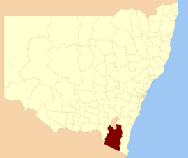
| Snowy Monaro Regional Council New South Wales | |||||||||||||||
|---|---|---|---|---|---|---|---|---|---|---|---|---|---|---|---|
 Location in New South Wales | |||||||||||||||
 | |||||||||||||||
| Coordinates | 36°13′55″S 149°07′48″E / 36.232°S 149.130°E | ||||||||||||||
| Population | 21,666 (LGA 2021)[1] | ||||||||||||||
| Established | 12 May 2016 | ||||||||||||||
| Area | 15,162 km2 (5,854.1 sq mi)[2] | ||||||||||||||
| Mayor | Chris Hanna[3] | ||||||||||||||
| Council seat | Cooma | ||||||||||||||
| Region | |||||||||||||||
| State electorate(s) | Monaro | ||||||||||||||
| Federal division(s) | Eden-Monaro | ||||||||||||||
| |||||||||||||||
The Snowy Monaro Regional Council is a local government area located in the Snowy Mountains and Monaro regions of New South Wales, Australia. The council was formed on 12 May 2016 through a forced merger of the Bombala, Cooma-Monaro and Snowy River shires.[4]
The council comprises an area of 15,162 square kilometres (5,854 sq mi) and occupies the higher slopes of the eastern side of the Great Dividing Range between the Australian Capital Territory to the north and the state boundary with Victoria to the south. At the time of its establishment the council had an estimated population of 20,707.[4] Its population at the 2021 census was 21,666.[5]
The Mayor of the Snowy Monaro Regional Council is Chris Hanna since 21 September 2023.[6]
- ^ Australian Bureau of Statistics (28 June 2022). "Snowy Monaro Regional (Local Government Area)". Australian Census 2021 QuickStats. Retrieved 28 June 2022.
- ^ "Snowy Monaro Regional Council | community profile". profle.id.com.au. 2023. Archived from the original on 17 May 2024. Retrieved 17 May 2024.
- ^ Cite error: The named reference
2023-24Mayorwas invoked but never defined (see the help page). - ^ a b "Snowy Monaro Regional Council". Stronger Councils. Government of New South Wales. 12 May 2016. Archived from the original on 22 February 2017. Retrieved 13 May 2016.
- ^ Australian Bureau of Statistics (28 June 2022). "Snowy Monaro Regional". 2021 Census QuickStats. Retrieved 17 May 2024.
- ^ "Councillors". snowymonaro.nsw.gov.au. 81 Commissioner Street Cooma, NSW 2630: Snowy Monaro Regional Council. 17 February 2022. Mayor Chris Hanna. Archived from the original on 17 May 2024. Retrieved 17 February 2022.
{{cite web}}: CS1 maint: location (link)